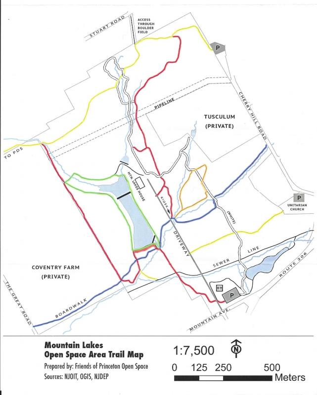
Mountain Lakes is 1 mile north of campus, and offers several miles of easy hiking trails. Mountain Lakes is an old estate, which explains the long, paved driveway leading to the old house at the center of the property on the edge of lake. Other features of the park include rocky streams, massive boulders, and elevated boardwalks.
Trail Map
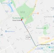
Walking from campus via Google:
From the corner of Nassau Street & University Place (the Rocky Dining Hall), turn left onto Nassau heading away from campus. At the next traffic light, turn right on Bayard Lane (rte. 206) and follow the road down the hill. At the gas station, cross Bayard Lane to be on the far side of the road— in the next block, the road will curve to the right, but continue straight on the sidewalk through some bushes. The sidewalk will turn into a road, and at the end of the block will be the entrance to Mountain Lakes.
Trails
Trails are well maintained and have color-coded markings along the trails that correspond with the maps.
For an introductory hike, take the driveway into the house and then walk down the house's front lawn to the lake. At the edge of the lake, you'll find the green trail that loops around the lake; there are few green blazes on the trail, but as long as you stick to obvious trails that are on the lake perimeter, you'll be on the right track.
For a long loop through the park, start at the parking lot on Mountain Ave and head counter-clockwise. From the eastern edge of the parkinglot, take the paved path briefly until a wooden plank marks the start of a trail into the woods. After crossing a stream, the white trail briefly hugs a pond before veering left to cross another stream. The white trail will then go through trees and a large field. Just before getting ot the paved road & house, turn right onto the red trail. Follow red until it joins with yellow (go straight/left on yellow). Yellow will lead through a boulder field before crossing white. For a short bonus loop, take the white trail to the right, up and over a stream, before rejoining yellow. Yellow will continue to near the edge of the park; after crossing a large stream, take a hard left to start the red trail. In a bit, red will briefly touch the green trail, giving the option to finish the loop via the lake perimeter. Otherwise, follow red to the boardwalk before turning back in towards the lake (via blue). From the end of the lake (reached either via green or red), take the red trail parallel to the driveway back out to the parking lot.
Additional Trail Information
Description from the New Jersey Trails Association Web Site - njtrails.org
The Mountain Lakes Open Space Area, a “central park” in Princeton, consists of some 400 acres just north of the center of town, most of it open to the public. It has a wide variety of hiking trails- and two biking trails – some connecting to other trails outside of the area described here. Along with views of Tusculum, the estate built by John Witherspoon, and historic Coventry Farm, it features a great variety of open fields, several small streams and lakes, old stone walls, boulder fields, and old growth pine and hardwood forests. The area is divided into five sections: The Billy Johnson Mountain Lakes Preserve, including the Mountain Lakes House; Mountain Lakes North; John Witherspoon Woods; the Tusculum fields; and Community Park North. Most of the remainder of Tusculum, to the east, and Coventry Farm, to the west, is private open space.
Three major northwest-southeast trails, 2 northeast-southwest trails and a major loop crisscross the Mountain Lakes Open Space Area:
- The 1.0 mile Stuart-Coventry View Trail (red markers) begins at the west end of the main parking lot and runs NW along the newly restored lower dam and then along the Coventry Farm boundary in The Billy Johnson Mountain Lakes Preserve before entering Mountain Lakes North and ending at the Stuart Crossing on the west inlet stream, where it meets the Stuart-Witherspoon Trail.
- The 1.1 mile Stuart-Witherspoon Trail (yellow markers) begins at the small parking lot on Cherry Hill Rd., runs SW through boulder fields (some huge rocks, including Devil’s Cave) and old growth forest in John Witherspoon Woods and Mountain Lakes North, crosses the west inlet stream at the Stuart Crossing, and continues along the Stuart Trail (private property- stay on the trail) to The Great Road. For longer hikes, across the road is the start of the PDS Trail (also on private property), which follows the PDS boundary to a connecting trail coming from Woodfield Reservation (see separate listing.)
- The 1.5 mile Pettoranello-Brookside Trail (white markers) crosses a dozen small and medium size streams (2 on bridges). It begins at the east end of the main parking lot and runs along several paved and unpaved trails in Pettoranello Gardens before entering the pine woods across the sewer line in Community Park North. From there it enters the Tusculum Fields, running NW through parts of the East Field and turning SW through the North Field, and then reenters the woods and turns NW again as it passes the ML House and drops down to the very pretty east inlet stream. Upon entering John Witherspoon Woods it makes a large loop on both sides of the inlet stream before ending at the John Witherspoon Woods Trail.
- The 0.7 mile John Witherspoon Woods Trail (red markers) begins at the trailhead kiosk halfway down the driveway to Mountain Lakes House (no parking.) Going down the steps to the east side, the trail runs north through various types of terrain and forest before entering John Witherspoon Woods and ending at the Stuart-Witherspoon Trail.
- The 1.0 mile Boardwalk-Tusculum Trail (blue markers) runs in both directions from the trailhead kiosk:
- To the east, it runs down the steps to an immediate junction, where it turns right and crosses several streams before entering the pine woods in Community Park North, then crosses into the Tusculum Fields and runs along the East Field to Cherry Hill Rd. (no parking.)
- To the west, as the only authorized bike path, it follows a maintenance “road” before entering the woods and then exits the Preserve and crosses some significant wetlands on a boardwalk built with funds donated by the J. Seward Johnson, Sr. Foundation. After some great views of Coventry Farm, the trail ends at The Great Rd.
- The 0.8 mile James Sayen Trail (green markers) is a loop that is entirely within the The Billy Johnson Mountain Lakes Preserve. It can be accessed from either the Stuart-Coventry View or the Boardwalk-Tusculum Trail, or from the lower lawn of the Mountain Lakes House, and it makes a complete circle around the upper and lower lakes.
- In addition, several shorter trails and spurs exist, including the Community Park North Trail (yellow markers), which begins at the Unitarian Church parking lot and runs through pine woods to the driveway, and the West Field Loop (orange markers), with views of the Tusculum estate.
- The sewer line (0.8 mile, no markers) enters the Area from Route 206 and runs west to a gate into The Glen (private) before reaching The Great Road. This is a wide, grassy swath which separates Community Park North into the pine woods on the north and Pettoranello Gardens on the south.